The Phoenix: Falmouth Rises from its Ashes as Portland
On October 18, 1775, Henry Mowat, Lieutenant in the Royal Navy, stood off in the Fore River in HMS Canceaux and, with four other vessels, bombarded the port-village on the peninsula of Machegonne within the town of Falmouth, Massachusetts. He had given warning prior to the bombardment, so no human lives were lost, but all the vessels at anchor in Falmouth Harbor were sunk or taken, and between two thirds and three quarters of the village was destroyed (totaling more than 400 buildings and homes). When describing the attack, George Washington, who received the news while in Cambridge, wrote to John Hancock that the burning of Falmouth was “an Outrage exceeding in Barbarity & Cruelty every hostile Act practised among civilized Nations.”
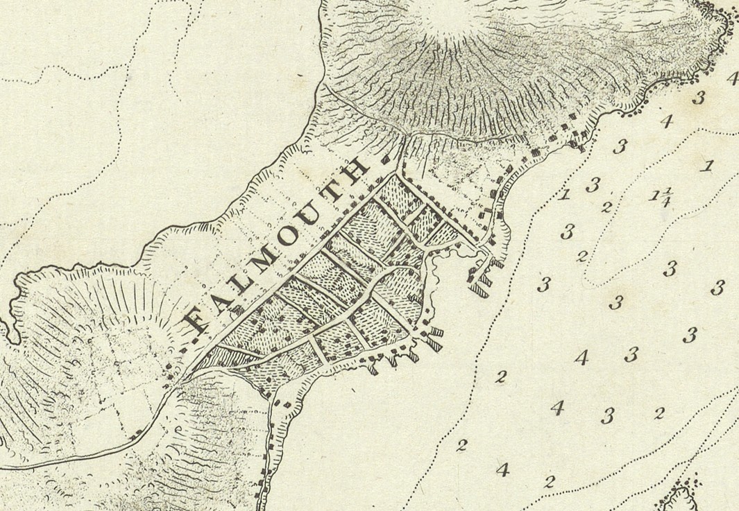
The event, which came to be known as the Burning of Falmouth, was a retaliatory measure for previous Patriot actions, namely the capture of HMS Margaretta in Machias the previous June. In many ways, Mowat’s attack was enabled by coastal charting and mapping. Mowat’s flotilla could navigate the Fore River safely because, a few years earlier, Mowat himself had sounded the river bottom for Samuel Holland’s survey of the coasts of the northern British colonies. It should be noted that when Holland’s map of the harbor first appeared in print, in 1776, it was already out of date! Holland’s chart actually shows the settlement before Mowat’s bombardment.
After the theater of the Revolutionary War moved west and south in the early 1780s, Boston publishers sought to remind New Englanders of why they needed to continue to support the ongoing war effort against the Crown. In their “impartial history” of the war, published in 1781/82, Nathaniel Coverly and Robert Hodge commissioned an “artist’s impression” of Mowat’s bombardment as a symbol of British perfidy. While not geographically accurate, the engraving captures the essence of a semi-rural port settlement engulfed in flames, with residents fleeing the attack.
After the war, the town of Portland set off from Falmouth in 1786, taking its name from Portland Head at the entry to the harbor. In 1820, the urban center of Portland became the capital of the new state of Maine, and in 1832 it was incorporated as a city when the capital was moved to Augusta. The new city’s motto, “Resurgam” (I will rise again), referenced Abenaki and French attacks on the area’s diffuse English settlement in 1676 and 1690, but especially its 1775 destruction by Mowat.
In his 1831–33 multi-volume The History of Portland, William Willis included as an illustration a map reconstructing Mowat’s 1775 bombardment, probably designed by Lemuel Moody. Willis used the destruction of the semi-rural colonial settlement to create a place that he called Falmouth Neck as the origin of modern, urban Portland. The map thus served as the foundation for Willis’ invented tradition that the modern city of Portland had a long colonial existence as a city, like Boston, or New York. The Moody-Willis map of the destruction of Falmouth Neck was reprinted several times, through 1865, as the foundational moment in Portland’s history, before the great fire of 1866 redirected the city’s historical fixations away from Mowat’s 1775 act of destruction.