When we hear the word “education,” our minds typically jump to the classroom and the activities that happen within a school. We as a public, however, are constantly learning about the world from the various spaces and texts we encounter and interact with outside of formal schooling. This “public pedagogy” reflects the dominant social norms of the time and shapes how and what we think about the world around us. The American Bicentennial of 1976 was at heart a pedagogical endeavor. Commemorative events and newly published visual and narrative materials about the American Revolution and the United States were opportunities to retell, reify, and celebrate a narrative of American exceptionalism. This was done in order to boost national morale and promote unity in the wake of the social changes of the Civil Rights Movement and its offshoots; the tumult of the Vietnam War, which ended in 1975; and the Watergate political scandal, which led to President Nixon’s resignation in 1974.
The American Revolution Bicentennial Administration (ABRA) and its predecessor, the American Revolution Bicentennial Commission, was an independent federal agency formed by President Lyndon Johnson in 1966, and that served as the central coordinating body for the United States Bicentennial celebration. While one of their stated goals in 1976, was to “reaffirm the basic principles on which this county was founded and to gain a new understanding of our heritage,” the cartographic objects included in this exhibition largely put forth a traditional progress narrative of American history in which a vast, mostly empty continent becomes populated by a white, industrious, self-reliant population of rugged frontier-folk who ultimately bring civilization and democracy to the untamed wilderness via Manifest Destiny. This narrative was particularly striking in 1976, as it largely ignored aspects of the contemporary Civil Rights Movement and American Indian Movement which both expanded and complicated our understanding of who and what America is. In fact, Black and Indigenous presence in these materials is largely limited, if present at all. The other pedagogical drive of the materials in this exhibition is the promotion of community and civic engagement, whether through attending Bicentennial events around the nation, or by taking part in community beautification efforts at the local level to restore a sense of national pride. Before the ABRA was disbanded in 1977, they claimed that 91% of all Americans had participated in at least one Bicentennial event.
Many of the Bicentennial objects displayed here have corporate sponsorships that further demonstrate how narratives of the Bicentennial were filtered out to the public. While some objects are related to the Bicentennial in name only, others present narratives about the past that are further legitimized by the inclusion of the official seal and logo of the American Revolution Bicentennial Administration. In the end, the importance of the Bicentennial was not necessarily constrained to how the past was made sense of and presented. Rather, the importance of the 200th anniversary of the Revolution was how the narratives on display were pedagogically used to position people to make sense of who/what the United States was in 1976 and who/what it should be in the future. As you reflect on the objects in this exhibition, questions you might ask include: Whose story is being told? What do these stories mean in terms of understanding how the Bicentennial was made sense of by everyday Americans in 1976? And, how do these Bicentennial narratives relate to the stories we tell about the United States today?
Growth of the United States
Created for the Bicentennial, and meant to be displayed in homes and classrooms, the pictorial map The Growth of the United States, sponsored by Exxon, reflects a long-held belief in Manifest Destiny–the idea that the nation was ordained by God to stretch across the North American continent from “sea to shining sea.” The term was coined and popularized by journalist John O’Sullivan in 1845, at the height of America’s westward expansion.
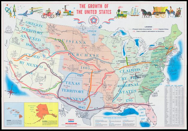
The front side of the map traces the territorial acquisitions of the United States, pedagogically promoting the idea of an empty continent waiting to be claimed by pioneers, and as a natural progression of the growth of the United States. Images superimposed on the map reinforce this idea, including: major routes used for westward expansion such as the Cumberland Road and Oregon Trail, as well as images of stereotypical pioneers, prospectors, and soldiers. By 1976, the expansion of the United States had been extended beyond the contiguous 48 states to Hawaii (1959 statehood), Alaska (1959 statehood), and the annexation of overseas territories such as Puerto Rico and the Philippines. These territories are only textually rendered, however, acknowledging them as part of the country, but separate from its corporality. There is little Indigenous presence on the map. Where it does occur, Indigenous people from various tribal nations are shown only in connection to white settlers, who occupy a more dominant visual space (typically standing over or above Indigenous figures). The progress narrative put forth on the map is mirrored by the imagery along the top border, showing the technological developments that facilitated U.S. territorial expansion from the arrival of the Pilgrims in 1620 to the creation of technology to open up America’s next frontier: Outer Space, which would have been at the forefront of people’s minds just seven years after the moon-landing.
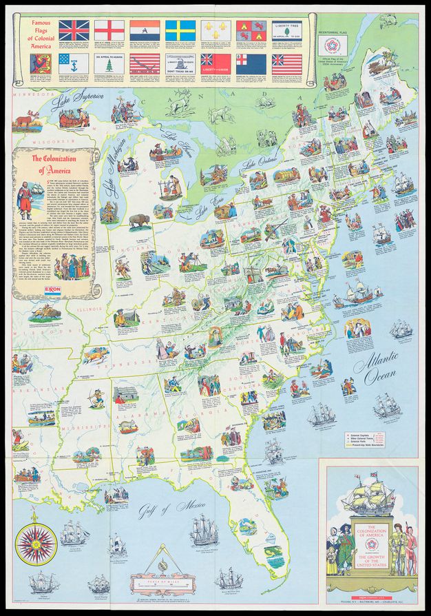
The verso of the map focuses on the colonization of the United States, with particular emphasis on the borders established at the end of the Revolutionary War in 1783. Within the narrative of the map, North America was explored by various Europeans until the English took hold in Jamestown. While Indigenous peoples are briefly mentioned as a threat, they are then depicted as beyond civilization, confined beyond the Appalachians, which are described as “the realm of the virgin forest, the wild animal, and the Indian.” The images on the map largely provide factoids about colonial life, focusing on exploration, daily life, and settler colonial “firsts.” Black Americans are also largely absent from the map, indicative of a larger absence from the majority of mass-produced Bicentennial materials. This map reminds us that we are taught History through images, as well as texts, and that visual narratives of Manifest Destiny were frequently presented on maps intended for personal and classroom use, long after the introduction of the concept in 1845, and certainly during the Bicentennial.